
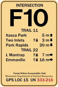
The Forest Riders Snowmobile Club members continue to make improvements to our fantastic trail system! The improvements include the new 2014 snowmobile trail map featuring more accurate GPS-tracked trails and the labeling of every intersection on our trail system. Throughout the trail system, the club has posted intersection signs and directional maps at each intersection. An example of the intersection sign is shown below. Our goal is to make the Forest Riders trail system one of the best in the state!
|
|
Each sign includes the intersection number, trail number, mileage to the nearest destination, and food/drink and fuel indicators. Posted at the bottom of the sign are the GPS coordinates for the intersection. In case of an emergency, call 911 and give these coordinates to the 911 dispatcher. This information will be then dispatched to area law officers, first responders, and medical personnel. |
New in 2015...Two five-mile sections of trail have been added to the 266 miles maintained by the Forest Riders. One section is a trail on the south side of Park Rapids connecting the trail on the west side of the city to the trail on the east side. The other section connects Trail #16 near County 32 to the Eagle Lake public access or County 89. A more detailed explanation is described below.
The first section, new Trail #35, is a route running around the south and east sides of Park Rapids from existing Trail #19 at the intersection of Highway 71 and County 15 running east along County 15 to Fish Hook Avenue then going north through county land to the corner of 12th Street and Eastern Avenue then north along Eastern Avenue and turning east along 8th Street to Henrietta Avenue. The last segment runs along the west side of Henrietta Avenue north past Highway 34 for about two blocks to existing Trail #11. From this point, riders can either go east to Trail #31 along County Road 4, or north to the Heartland Trail, or west to the Red Bridge.
The second section is an extension of Trail #16 from the Becker County line going east through two privately-owned properties, whose owners have graciously given permission to the club to groom on their property, then runs east across county and state land to Highway 71 and south to the public access on Eagle Lake or north to County 89. This addition eliminates a dead end on the trail system and connects the east and west sides of Highway 71, if ice on Island Lake is not good.
Thank you local businesses! The club wants to extend our thanks to local businesses for purchasing map ads and sponsoring portions of the trail system. Maps are now available at all of the participating businesses. Snowmobilers...remember to support your local businesses!!